Talk:Galaxy
From Gineipaedia, the Legend of Galactic Heroes wiki
Non-LOGH graphics
Fan created graphics such as the zoom, and the non-LOGH related graphics are not canon and I don't think they should be included as under the canon policy they fall under "invalid sources" and "Information from these sources should not be used in any capacity in articles on Gineipaedia, nor should they be linked to or even referred to." Also just pasting a big blob of real life astronomical information is not directly relevant to LOGH either. If someone wants to look up information on the Milky Way there are plenty of outside sites they can use to do so. The wiki should confine itself to direct LOGH related information, not general physics and astronomy. Iracundus 13:41, 13 August 2012 (UTC)
- Removed as wished. Almael 16:06, 13 August 2012 (UTC)
Size/structure of the human territory
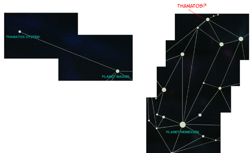
Among (many) other things, I'm currently trying to work out the "size" of the galaxy. I've slapped a number of screens from the Spiral Labyrinth OVAs together to make this:
As you can see, the exact location of the Thanatos Starzone is not explicity shown, but from the shape of the corridors indicated and the location of the 'camera' when the map scene changed, I've indicated where it SEEMS to be located. The scale is probably a bit big.
Anyway, the distance between Heinessen and Thanatos is stated at being 480 light years. We'll assume this is the most direct distance to measure, not the distance ships would have to travel to get there. If that's true, we can estimate the longest length of the Alliance territory to be about 500LY.
Furthermore, additional maps indicate Odin and Heinessen are roughly equidistant from the Iserlohn Corridor, and roughly equal in size. Meaning that it's 500LY from Heinessen to Tiamat, and roughly another 500LY from Tiamat to Odin.
Arle Heinessen's Exodus is often described as a journey of 10,000 light years.
What all of this means is that, if we view the galactic plain, we have both the FPA and Empire occuping mostly circular territories with diamters of 500LY. I would be liberal and say that the overall amount of colonized space would be roughly equal to a 12,000LY diameter circle.
If the galaxy is true to current estimates (total-size wise) that means that humans have settled/explored between 5% and 10% of the galaxy. This fits in with the stated border between the two nations being the "rift" between the Orion and Sagittarius arms, which may old various implication for other logh concepts, like warp.Canary 08:25, 12 May 2011 (UTC)
- I have been meaning to look into this myself recently. There are several points in the series where they give ly distances and/or travel times, so i think we could definitely piece together a pretty good picture of things. As you mentioned, it would also help us understand how fast 'warp' is in LOGH ♥ kine @ 09:03, 12 May 2011 (UTC)
- they mention travel times quite often in Spiral Labyrinth... unfortunately, the times are all inflated due to layovers and delays and crap.
- I have a feeling the animators had a single large "map" that they moved around for all of the map scenes... meaning that the map from one episode should be the same scale as the map from any other... meaning that, in theory, we ought to be able to reconstruct the entire map used in the OVAs (similar to what I did above, but more complete).
- Ideally, I'd like to be able to reconstruct the complete map and use THAT for the Galaxy page instead of any fan-created maps. Canary 18:38, 12 May 2011 (UTC)
- The problem is not the maps shown perse. The problem is the maps shown only show the major lines (structure) and systems. The smaller systems along or between are not shown, but are shown on regional tactical maps. The major map structure is consistent everywhere, but vary in the exact distance or are skewed due to screen size differences. It shouldn't be a problem to identify the major systems shown, but the minor systems are mostly unknown. Almael 15:04, 20 August 2011 (UTC)
- That shouldn't bee too much of an issue, as the overall maps are consistent in shapes, and the more regional maps typically show enough to give us a crude idea of how they all fit in on the complete map. Perfect accuracy may be too much to ask for, but no matter what, there are going to be problems and inconsistencies because we're representing a 3D map on a 2D image. We can't assume that the maps we see on-screen are from the same angle. It's entirely possible that the maps we see don't indicate geographic position at all, but rather each starzone's relative distance from its neighbors.
- Ah, well. I'll figure something out. Canary 01:53, 9 January 2012 (UTC)
- Both are direct from the DVD features and are as canonical as it gets. Not all the place names are placed in locations, but major systems are. Iracundus 08:28, 9 January 2012 (UTC)
- Sorry, but I reviewed them long before and they are not quite consistent with others either. Some are misplaced. The newest maps from the new ovas are also different. There seem to be a number of type inconsistencies for all the maps. Some show closer details while dismissing some major lines. Others have problems at the rims of the nations. All in all we can only be sure about the main connections, the semi major connections vary. The star system name placement vary. The 3D isn't that of a problem from ep.6 In any case the known universe is really small if you map it out on the real Galaxy about 1/50. Almael 00:59, 4 August 2012 (UTC)
Star charts
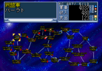
So, i don't know if this is useful, but take a look to the right there. Found this in the LOGH III game for the PC-98. Granted video games based on anime or TV shows are usually completely made-up, but most of this seems plausible. One thing that sticks out for me though — Tiamat should be on the other side, shouldn't it?
edit: OK, here is another game screenshot for comparison. This one is from the Saturn game. I've included both the original screenshot and a rotated one (since it was not the same orientation as the PC-98 one). Something to note about this one: It contains several systems that (unless they are in Spiral Labyrinth or something) are purely made up for the game.
edit: lol, here's another. This one is from the PSX game. Incidentally, any misspellings are intentional on my part — this game has (attempted) translations included, so i've preserved their spellings here. (This will be useful for a few pages' name variations eventually.) ♥ kine @ 01:24, 15 May 2011 (UTC)
- At the start of some of the Silver White Valley episodes they have charts that show the major planets of both the Empire and Alliance. Would those work?Strayor 20:48, 26 November 2013 (UTC)
- Wow, there are such charts? That would be great!FPA Forever
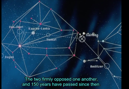
- Hmm, I did some checking but all I could find was a portion of the star chart showing the relative positions of the frontier systems between the Alliance and the Empire around the Iserlohn Corridor at the start of SWV: 'Chapter II'. So I do not think that would work, sorry. =( Glacierfairy 00:52, 29 November 2013 (UTC)
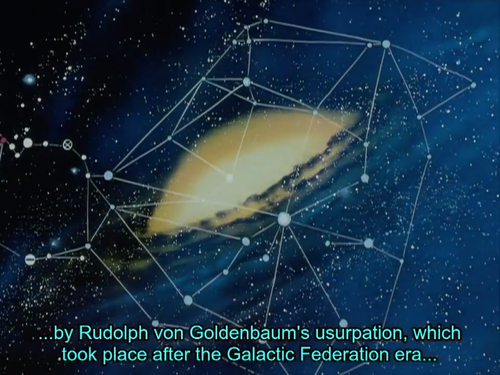
- That's not the scene I am referring to and I'll look around for it but somewhere in SWV there is a complete chart that scrolls from Empire to Alliance and because it is the only time I can remember the entirety of both the Empire and FPA being fully viewed on screen at any one time I think it is permissible. Granted, nothing is labeled, but the charts are accurate enough to have someone like myself, who had only viewed the series from start to finish a few times, to be able to easily pick out Heinessen and Odin in them. I can't guarantee that they will match up with other charts that are seen, but the basics are all correct and I believe it is a great starting point for us to fill the information in with. I'll find it. Strayor 03:10, 29 November 2013 (UTC)
- Ok so at 8:45 or so in SWV: 'Chapter II' they show the map that I am referring to. It shows all major routes and systems of both the Empire and Alliance. From what I know, I believe that this is easily the best place to start when trying to map the LOGH era Milky Way, and in my opinion is worthy of being used as the reference for the locations of various systems and the picture for the galaxy page itself. We can also pair other smaller, more detailed charts with this one and be able to further identify where everything is. I really hope we can use this. It bugs the hell out of me that we don't have an all encompassing map for this site. Let me know Strayor 03:21, 29 November 2013 (UTC)
- I took a few screen shots but it is difficult as it is fading to the next scene when moving over the Alliance and I am stuck with subtitles on the screen as well. Even so I will post what I have so you guys can see what I am talking about. If I can figure out how that is. Strayor 03:31, 29 November 2013 (UTC)
As you can see, the fades are problematic for screen capture even if the subtitles were to be removed. If there's no way to clean that up then I propose that we use the info we gain from this scene and make a galaxy chart. I think making a simple diagram would suffice and I would also volunteer to make it. While the product will itself be "fan-made" the knowledge provided will all be strictly based off of canon, and I think it would be helpful to have some form of a complete chart. Seeing as though charts are merely circles representing systems with straight lines connecting them in various ways, I do not think this is either too difficult or too against the canon standards. Strayor 03:49, 29 November 2013 (UTC)
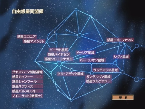
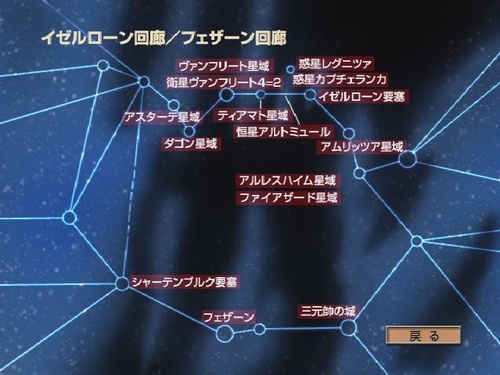
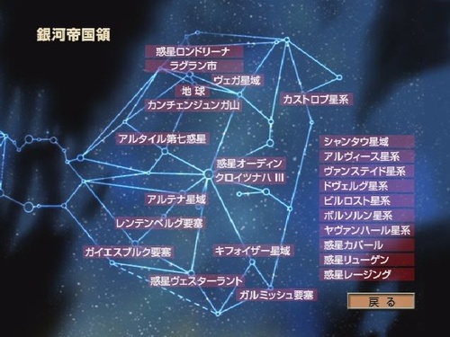
The above 3 are from the DVD features. The list of systems on the side of the Alliance and Empire maps denotes systems whose locations are not known or shown on the map. Iracundus 07:27, 29 November 2013 (UTC)
- Now that's what I talking about! Well we now have all of the info required to have a fairly detailed chart of the entire galaxy. Do you just want to use the three you just put up and then superimpose the English translations over the Japanese and edit it a bit or would you prefer to have one made from scratch that is directly based off of these charts that have been provided? Or a better question would be to ask if anyone has any other ideas? Strayor 16:29, 29 November 2013 (UTC)
- Wow. In English, those charts would be incredibly useful for something I'm doing. Can someone translate these? As for the map, maybe one made from scratch would be fun, if there was someone with the artistic know-how.FPA Forever
- The best I can think to do that would be to try and find a scene that shows the regions of the Sagittarius and Orion arms where the series takes place without the charts over them. I vaguely remember such a scene. I'm watching them all again so I'll keep it in the back of my mind and see if I can find one. Then we could do our own charting and labeling, but still if there was a way to directly translate the Japanese without marking up the original charts too much I think we should go down that route. I can give it a try but I'm no graphic designer or anything. I would need the translations first though. Strayor 21:15, 30 November 2013 (UTC)
- For the 2 corridor map since it's the shortest: (top row, left to right) Astarte starzone, Dagon starzone, Van-fleet starzone, satellite Van-fleet 4=2, Tiamat starzone, Planet Altmül, Planet Legnica (the little circle floating above the main corridor), Planet Kapche-Lanka, Iserlohn fortress, Amritsar starzone
- Middle row (column of two, unclear exact location): Arlesheim starzone, Firezard starzone
- Bottom row (left to right): Schattenburg fortress, Fezzan, Fortress of the 3 Fleet Admirals (Die Festung "Drei Großadmiralburg"). The two planned fortress locations at either end of the Fezzan Corridor have schematic drawings shown so unclear if they were ever actually built. As for the other two maps, the names are all in katakana. It's actually possible to do the translation based on what are the known systems and using the katakana provided in the various articles here.
- Oh and I don't know why I didn't check earlier but the star system for Heinessen is actually Baʿalat, not Barlat, after the Babylonian goddess. I guess that requires modification of everything that makes reference to "Barlat" then. The other planet in the system where Yang mines the ice for his attack is called Srinagar. Ba'alat starzone, Planet Heinessen, and Planet Srinagar respectively top to bottom is the translation for 3 over the big dot in the Alliance map. Iracundus 23:25, 30 November 2013 (UTC)
- Thank you for putting everything up. I'll get to work and see what I can do. It may take a few days as I am particularly busy in the immediate future but I will get it done and posted asap. Strayor 19:05, 1 December 2013 (UTC)
- For the rest of the Alliance territory, the column on the far left is Dayan Khan Space/Supply Base, Planet Kaffer, Planet Shampool, Planet Nephthys, Planet Palmelend, and Neue Land.
- On the rest of the map, the upper left two (from top down) are Planet Econia, and Planet Masjid. Upper right is Planet El Facil. Between Heinessen and El Facil is Doria Starzone. Directly beneath El Facil is Siva (sic) starzone. Below Doria is Starzone Vermilion. Below that is Starzone Rantemario, Gandharva system, and Planet Uruvasi. Between that group of 3 and Heinessen is Starzone Marr-Adetta Starzone. Iracundus 23:25, 6 December 2013 (UTC)
- For the Empire, the upper right is Castrop system. The big dot in the center is Planet Odin and Kreuznach III. The upper right has Planet Londorina (sic?), City Lagran, Starzone Vega, Planet Terra, Mt. Kangchenjunga. Then just to the upper left of Odin is Planet Altair-7. Moving to the lower left from Odin is Starzone Altena, Rentenberg fortress, Geiersburg fortress. Immediately to the right of Geiersburg is Planet Westerland, then moving to the upper right Starzone Kyffhäuser. Below that is Garmisch fortress.
- The column on the far right is from top down Starzon Schann-tau, Alviss system, Wansteidt system, Dverger system, Bilrost system, Borthorn system, Jafnhár system, Planet Kappahl, Planet Lügen, and Planet Lesing. Iracundus 23:36, 6 December 2013 (UTC)
- Thanks again for all the info. I had to go out of town for a few days but now I'll get to work on it. Thanks for the patience. Strayor 21:26, 9 December 2013 (UTC)
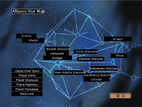
When I converted the file from .idraw to .svg it changed the text positions for some reason and had them appear out of the boxes like that. I'll try to convert it to other forms to see if that fixes it. As far as the style and overall format I would like to know if you guys think it's good enough or if should I keep working on it to try and erase the original translations completely and add the opaque effect with some copied stars from the other parts of the chart behind it. I want to use this first map to figure it all out before I start on the others. Let me know. Strayor 22:30, 9 December 2013 (UTC)
- Interesting... does this means that Masszitt should actually be written as "Masjid"? Glacierfairy 01:59, 10 December 2013 (UTC)
- That's right. Masjid is Arabic. And in episode 47, a system (which is not shown on the map) is named Jamshid, after the Iranian/Zoroastrian king/mythological figure. Took awhile for that one to click. Iracundus 12:33, 10 December 2013 (UTC)
- Are you guys ok with our star charts looking this way? If all the text was better in line of course. Strayor 13:41, 10 December 2013 (UTC)
- Since I fixed the text out of boxes issue and haven't received any feedback I am going to go ahead with the Corridor and Empire star charts. Please let me know of your opinions on the Alliance map and the pieced together map that will be the first finished project. Thank you. Strayor 14:31, 11 December 2013 (UTC)
- I think it looks fine. It accomplishes the main purpose of allowing a reader a general idea of where everything is. All else is bonus aesthetics. Iracundus 01:44, 12 December 2013 (UTC)
No longer just a talk page. Let me know what you think. As far as the sizing for the chart on the page, the proportions change when I scroll in or out making it difficult to judge the "proper" number of pixels to type in. If somebody using a "default" zoomed browser could resize that for me so it matches the page's width it would be most appreciated. I also have the charts for the individual regions as well if we want to throw them in to the Empire, Corridor, and Alliance articles. Let me know. Strayor 19:00, 12 December 2013 (UTC)
I also just realized that it says Alliance star map and not Neue Land star map so I could change that or do you guys think I should leave it as is. I know the wiki contains all the spoilers but a map for reference is something that someone wanting to avoid spoilers should be able to access without worry. I think that since Neue Land appears already in the column we should leave it labeled the Alliance map. Strayor 19:13, 12 December 2013 (UTC)
- Keep it Alliance as that is what the map said originally. Iracundus 12:09, 13 December 2013 (UTC)
